


Arduino Precise Distance Measurement
Product Number:M88B-60m(k190909mr-2)
Laser type: 620-690nm
Frequency: 3Hz
Measuring Range:0.03-60m
Accuracy:+/-1mm
Size: 45+25+12mm
Weight: About 10g
This laser measurement sensor has long measuring distance, small size, low-power consumption design, long-life, so that it can reduce the frequency of device replacement, and reduce management costs.Also, this laser sensor uses a phase ranging laser rangefinder. According to the ranging method, the laser range finder can be divided into a phase range finder and a pulse range finder.
60m Arduino Precise Distance Measurement Sensor
This laser measurement sensor has long measuring distance, small size, low-power consumption design, long-life, so that it can reduce the frequency of device replacement, and reduce management costs.

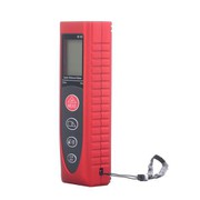
Front

Backside
60m precise laser distance measurement
Product Description:
This product uses a phase ranging laser rangefinder. According to the ranging method, the laser range finder can be divided into a phase range finder and a pulse range finder. The basic concepts used in laser range finder are basically the same. The range finder can emit laser beams with the push of a button. Those beams are reflected from distant objects. The high-speed clock measurement of the range finder is from the time the beam leaves the device to the return. The total time spent. The phase method laser range finder detects the distance by detecting the phase difference between the emitted light and the reflected light propagating in space.
application area

Pick vegetables and fruits

Transportation robot survey

Industrial automation ranging
Products Specifications

Product feature and application:
Product feature:

In forestry:The laser measuring instrument is combined with GPS, GIS and its software to carry out environmental monitoring with a portable computer. Data collection is used for forest resource inventory, that is, tree height, height of commercial materials, vegetation mapping, wild special tree species, excellent tree species positioning, determining the grade and economic value of trees in the area, or repairing cultivation management studies. Branches, determine the position of the tree at a particular height, map the amount of logging, and determine the resource boundaries; determine the topography of the timber channel for the consolidation of the timber channel, draw it, and serve it for general purposes. Pre-construction surveys of roads and rugged trails are important. If you use previous routine surveys, aerial photography and GPS positioning, you may encounter problems with cost, accuracy, and obstacles.
| Picture Show |

Products FAQs

Chengdu JRT Main Ranging Sensors: Industrial Laser Distance Sensor, Laser Distance Meter Sensor, Long Rangefinder Module, TOF High Frequency LiDAR Sensor.
For more info, please feel free to contact us
Hot Tags: arduino precise distance measurement, China, manufacturers, suppliers, factory, wholesale, customized, cheap, quotation, OEM, low price


Send Inquiry